5 Maps That Capture the Evolution of the World Throughout History

Maps, says Great Maps author and historian Jerry Brotton, are more than a geographic object, a tool to get us from point A to B. From the ancient Greeks to Google Earth, all human cultures have had an innate urge to map.
But historically, maps were inherently shaped by the people who create them — and used to accomplish geopolitical ends. Brotton's Great Maps, a visual overview of the history and politics of geography, teases out this goal. In Brotton's mind, you can examine the history of how the world viewed itself by looking at our maps.
"Every time I hear someone say 'Middle East,' it's hugely offensive because it's a Western concept," Brotton told Mic. Technically, any world map is a distortion because mapping the shape of the globe is mathematically impossible.
This poses some interesting questions for how we read maps. For example: Why do we put "north" on the top of maps? The, according to Brotton, is that "there's no rationale."
In ancient Chinese maps, the emperor is illustrated at the top as he looks down, southward, at his subjects. In the medieval age, it was rare that cartographers put west at the top because west is where the sun sets, signifying a place of death and darkness. In maps with heavy Christian influences, the east is illustrated at the top because, according to biblical scripture, the Garden of Eden is in the east. One ubiquitous logo attempts to avoid this issue entirely. Then there are famous maps like McArthur's Universal Corrective Map of the World, which represents an "upside down" view of the world that veers a sharp right from cartographic conventions.
Brotton chose more than 60 maps for his visually stunning book, an attempt to explain our urge to map and orient ourselves. There are five, Brotton says, that capture the evolution of maps throughout human history, shown below.
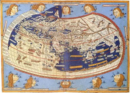
1. Claudius Ptolemy, 13th Century, world map
The father of geography. The Greco-Egyptian writer and scholar, Claudius Ptolemy, is known as the "father of geography." He drew from more than a thousands years of classical learning to develop one of the world's first global maps, with Europe at the center. Ptolemy's world had yet to recognize the Pacific and an American landmass.
Fun fact: Ptolemy is recognized for conceptualizing this world, but he only described it in his book, Geography, and ironically, didn't actually draw the map. His book also instructed cartographers to use a grid of intersecting lines known as the graticule.
2. Muhammad al-Idrisi, 1154, circular world
The first fusion of East and West. Al-Idrisi's celestial view of the world is considered one of the most advanced ancient maps. It is important to note his background, Brotton said. The Muslim scholar and exile who lived in Sicily worked on his cartography with a French king. He fused Islamic and Western notions to create his circular world map. It is considered one of the most advanced ancient maps.
3. Martin Waldseemüller, 1507, the first map to name America
The birth of America. Waldseemüller is credited with the first recorded usage of the word "America." Navigator and cartographer Amerigo Vespucci is honored and seen at the top right corner of this map by Waldseemüller. After publishing this map, he never used Vespucci's name again.
"He had second thoughts and doubted Vespucci," Brotton said.
Fun fact: The map was lost and only rediscovered in 1901 by a Jesuit priest. The U.S. Library of Congress bought it for $10 million from a German count who wanted to use the money for the expansion of his golf course.
4. Halford Mackinder, 1904, the Geographical Pivot of History
The birth of geopolitics. Geographer Halford Mackinder could be blamed for every geopolitical mess around the world. If you want to have political power, you have to control Eurasia, Mackinder noted about his map. But diplomats like Henry Kissinger and Cyril Radcliffe, the architect of the bloody 1947 India-Pakistan partition, were Mackinder fans.
5. Google Earth, 2011-Present
The real world. Whether it's about the nearest Chinese restaurant near you or directions to a friend's apartment, many of today's online inquiries have a geographic component.
Google Earth and the app Google Maps represents "the first time in world history where a private corporation has come to monopolize mapping," Brotton said. Maps' transition to the digital realm is just as revolutionary as its production on the printing press.
"What Google and Apple are fighting over in recent years are purely driven by commercial interests," Brotton said.
He also had some words of caution, which is to be skeptical of maps.
"The paradox of a map is that you can never have an objective and exact representation," Brotton said, "yet we can't live without one."