Will We Even See Snow in 2015? Here's the Deal With the Unusually Warm Weather

The weather this fall, or technically the meteorological winter as of Dec. 1, has been weirdly mild — so mild that wearing a winter coat still feels somewhat dramatic and unnecessary as we approach mid-December. Forecasters predict temperatures in regions across the United States will reach 30 degrees above average this weekend, with no prediction of a cold front or significant snowfall in the near future.
Why the winter delay? The U.S. is experiencing the effects of one of the strongest El Niños on record, which forecasters are saying is one of the main factors causing record high temperatures in some regions, and may weaken the possibility of a white Christmas, the Weather Channel reported. December has already broken several daily records for temperature highs in cities across the U.S.
There is a storm forecasted over the weekend for the southern Plains, something that would normally spell big snowfall this time of year in farther north, however above average temperatures have debilitated those chances, the Weather Channel reported.
El Niño bringing the heat: This year's El Niño is particularly strong, causing some of the highest Eastern Pacific Ocean temperatures of any El Niño ever recorded, according to Weather Channel meteorologist Domenica Davis.
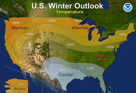
The National Oceanic and Atmospheric Administration released the U.S. Winter Outlook in October, predicting that El Niño would be major influence on winter weather — but not the only influence.
"A strong El Niño is in place and should exert a strong influence over our weather this winter," Mike Halpert, deputy director of NOAA's Climate Prediction Center wrote in the release. "While temperature and precipitation impacts associated with El Niño are favored, El Niño is not the only player. Cold-air outbreaks and snow storms will likely occur at times this winter. However, the frequency, number and intensity of these events cannot be predicted on a seasonal timescale."
The warm temperatures El Niño brings the U.S. will last through December, David predicts. Regions including the East Coast, Ohio Valley, Great Lakes and Northern Plains shouldn't see a significant drop in temperature until January, according to the Weather Network.
A storm will hit the Pacific Northwest region this weekend, the Weather Channel reported, but above average temperatures will likely prevent snow from accumulating. A mid-December storm of this caliber would typically cause significant snowfall in that region, according to the report.
Regions east of the Rockies from the Oklahoma-Texas panhandles to Wisconsin and the Michigan may see snowfall when the storm hits this weekend, but less than six inches if that.
Stop dreaming of a white Christmas: On average, past Decembers that experienced strong El Niños saw significantly warmer weather than average and therefore not much snow, the Weather Channel reported.
Regardless of El Niño, data collected by the National Oceanic and Atmospheric Administration between 1981 and 2010 show that even U.S. cities that experience the most snowfall have less than a 50% chance of a white Christmas.
Boston — 21%
Pittsburgh —30%
Chicago — 42%
Cleveland — 45%
Detroit — 46%
Record warm temperatures: Daily record highs have already been broken in Michigan, Oregon and Minnesota, among other northern states that tend to experience cooler weather, the Weather Channel reported.
The arctic jet stream, which would usually have moved over the U.S. by now, is still contained in Canada, the Weather Channel reported, locking in colder temperatures north of the U.S. border.
New York will see low temperatures in the 40s and 50s this weekend, several degrees warmer than the average low temperatures of mid-30s in the area at this time of year. "There are no signs of any major blasts of cold air reaching the U.S. in the near future," according to the Weather Channel.
Freezing temperatures await: The warm weather is no match the usually brutally cold months January and February. The Weather Network predicts a change in the jet stream pattern in late January heading into February will cause cold weather from the Great Lakes to Southeast similar but not as consistently harsh as last year.
Regions including the Southwest, Southern Plains, Southeast and the Atlantic seaboard will experience below average temperatures with the change in the jet stream while the Pacific Northwest, Northern Plains and Upper Mississippi Valley will continue to enjoy above average temperatures, according to the Weather Network.