Mystery of Nazca, Peru's Puquios: Satellite Images Shed New Light on Ancient Aqueducts

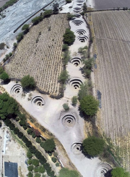
For years, spiral-shaped holes, called puquios, that dot the dry landscape in Nazca, Peru, have confused archaeologists. But now, the BBC reports, a team of researchers using satellite images has mapped out the spread of the puquios, including previously unknown holes.
Read: Astronaut Scott Kelly Grew 2 Inches in Space and Aged Less Than People on Earth
The puquios are part of a "sophisticated hydraulic system constructed to retrieve water from underground aquifers," Rosa Lasaponara of the Institute of Methodologies for Environmental Analysis, in Italy, who conducted the research, told the BBC. "What is clearly evident today is that the puquio system must have been much more developed than it appears today."
Lasaponara and her team used satellite images to analyze the placement of the puquios and realized the extent to which they moved water throughout the region. There is a system of tunnels underground, connecting the puquios. Each spiral hole pulls air down into the canals, moving the water through the network and bringing it to people who would have used it for both agriculture and domestic life, Lasaponara told the BBC. A more complete idea of how the puquios are connected also gives clues about when they were created, an issue long debated by archaeologists.
To design such a system would have meant that the ancient Nazca people who built them had extensive knowledge about the geography of the area, Lasaponara told the BBC. The irrigation tunnels may also be connected to the Nazca lines, giant geoglyphs of animals, people and shapes carved into the Nazca desert, Lasaponara told the BBC.
Lasaponara's research will be published in Ancient Nasca World: New Insights from Science and Archaeology this year.
April 14, 2016, 10:27 a.m.: This story has been updated.
Correction: April 14, 2016