Stunning Before-and-After NASA Images Show the Impact of the World's Greatest Threat

Climate change has progressed beyond the theoretical into the here and now, affecting every corner of the globe. Scientists are concerned about everything from rising sea levels to (now confirmed to be irreversible and potentially catastrophic) to atypical, long-lasting droughts. These photos from NASA's "State of Flux" series show us some effects of the globe's rising temperatures.
1. Pine Island Glacier calving, Antarctica
Between Nov. 9 and Nov. 11, 2013, an iceberg estimated to be roughly 35 by 20 kilometers (22 by 12 miles) separated from Antarctica's Pine Island Glacier. Usually this happens about every five years, but the "B-31" iceberg is 50% larger than its predecessors.
2. Wildfires in Alaska
In 2012 and 2013, fires burned areas on both sides of the Tanana River south of Fairbanks, Alaska. The red area on the left is the impact of the Dry Creek Fire, which burned 48,000-plus acres in summer 2012. On the right is Stuart Creek 2 from June 2013, which burned 85,000 acres. According to NASA, "Extreme terrain, high vegetation and dry, windy conditions have impeded firefighting efforts. More than 70 wildfires have burned more than 1 million acres in Alaska so far during summer 2013."
3. Cotopaxi Volcano, Ecuador
At 5,897 meters (19,347 feet), Cotopaxi is one of the tallest active volcanoes on the planet. On top of it sits the Cotopaxi Glacier, whose meltwaters provide drinking, irrigation and hydroelectric water supplies to the capital city of Quito. According to NASA, "The ice mass decreased 30% between 1956 and 1976, and another 38.5% between 1976 and 2006, a phenomenon tightly linked to global climate change." The image on the left is dated 1976, while the one on the right is from 2006.
4. O'Higgins Glacier melt, Chile
NASA says that almost all the glaciers in the Patagonian ice field are melting. These images depict the O'Higgins Glacier, which comprises one-fourth of the entire field, retreating over the period from Nov. 9, 1973 to Oct. 8, 2007. Between the start of the 20th century and 1995, it shrunk about 15 kilometers (9 miles). It's melting even faster as the world moves into the 21st century.
5. Ice melt in Uganda and the DRC
Glaciers have existed for thousands of years in Uganda and the Democratic Republic of Congo on the Rwenzori Mountains, located right along the equator, in one of the hottest places on the planet. But they might not survive for much longer, having shrunk by half between 1987 and 2003 (pictured). While they originally covered some 6.5 square kilometers (2.5 square miles), researchers say the glaciers will disappear forever within two decades.
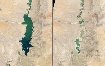
6. Elephant Butte Reservoir, New Mexico
Elephant Butte Reservoir reached its lowest levels in 41 years in the summer of 2013, even though monsoon rains occurred in early July. From 1985 to 2000, the reservoir was mostly full; the image on the left shows the reservoir at 89% capacity in 1994. Mountain runoff in spring 2013 was well below average, and coincided with anemic rains throughout the beginning of the year, leaving 80% of New Mexico fighting "extreme" or "exceptional" drought.
7. McCarty Glacier melt, Alaska
On the left is the McCarty Glacier in southern Alaska on July 30, 1909. On the right is the same location, Aug. 11, 2004.
8. McCarty Glacier melt, another view
Left: July 30, 1909. Right: Aug. 11, 2004.
9. Ice melt, Greenland
In 2007, NASA discovered a new island off the coast of Greenland that had previously been hidden under thick layers of ice.
Left: Aug. 11, 1985. Center: Sept. 5, 2002. Right: Sept. 4, 2005.
10. Bear Glacier melt, Alaska
Bear Glacier has been shrinking for decades, with the images proceeding left to right from June 5, 1980; May 16, 1989; and May 13, 2011. The last image shows considerable glacial retreat.