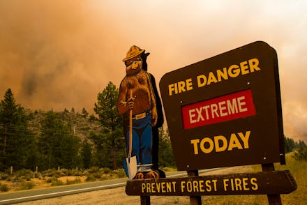
Wildfires are creating their own weather now, which is not great

Wildfires like the ones raging across the West coast of the United States can bring death, destruction, and degradation of the delicate balance of ecosystems. But these latest blazes are burning so intensely and growing so large that they are bringing something unexpected: their own weather patterns. According to a report from The Guardian, the fires currently plaguing Oregon and California are creating weather systems that are responsible for unpredictable events like fire tornadoes and massive traveling smoke clouds.
What typically happens with wildfires is the smoky clouds the blazes produce can result in the creation of something known as a pyrocumulus cloud, or fire cloud. AccuWeather Meteorologist Joe Curtis describes these as being "similar to a normal cumulus cloud, but it is formed through large amounts of smoke from nearby wildfires," which results in lots of thick, smoke-filled air rushing toward the sky.
A similar effect happens during volcanic eruptions, so the phenomenon is not unheard of. But the longer these wildfires burn out of control, the larger the cloud grows. As it gets bigger, it can start to generate its own weather, which typically exacerbates the conditions on the ground. As these clouds grow they morph into pyrocumulonimbus clouds, an evolved form of the fire cloud, that can create massive thunderstorms, lead to lightning strikes that spark more blazes, and bring strong winds that help the wildfire spread — none of which is particularly helpful for those trying to put out the blaze.
In some cases, these clouds can create extremely dangerous weather events like fire tornadoes, similar to the one that was caught on camera spinning in California last year as the state suffered from one of the worst wildfire seasons on record. These clouds are believed to be in part responsible for creating the massive haze of smoky and dangerous air that has made its way all the way across the country and settled over cities like New York City and Philadelphia, according to NPR. All of this results in dangerous conditions for those in the path of the fire and firefighters attempting to stop or slow its spread.
"The fire is so large and generating so much energy and heat that it's changing the weather," Marcus Kauffman, a spokesperson for the Oregon Department of Forestry, told The New York Times. "Normally the weather predicts what the fire will do. In this case, the fire is predicting what the weather will do."
These fire clouds have been on the radar of experts for weeks, and appear to only be getting worse. Per The Guardian, researchers at the Naval Research Laboratory have been tracking a record number of these pyrocumulonimbus clouds, and they have been doing noteworthy damage across the West coast. The National Weather Service in Boise, Idaho warned last week that these clouds have been creating lightning in Oregon and Idaho as the massive Bootleg fire continues to burn in both states.
If there is any good news to be found in these clouds (it's not recommended to go checking for silver lining in these things) it's that they can sometimes generate rain. At this point, that might be the best bet to fight the blazes, which continue largely undeterred. The Bootleg fire out west has already scorched over 400,000 acres of land and is just 40 percent contained, according to the National Wildfire Coordinating Group. Tens of thousands of residents have been evacuated and hundreds of buildings, including residential homes, have been lost to the blaze. As we head toward a dry season out west, the best bet might be hoping for these fire-created weather patterns to generate their own rain, because otherwise help does not appear to be on the way.