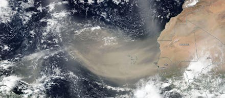
2020 has been a year of inexplicable and untimely horrors, from the still increasing death toll caused by the coronavirus pandemic, to the introduction of murder hornets in the Pacific Northwest, to the ongoing strife caused by racism and inequality across the country. So what's one more chaotic anomaly on top of all that?
The latest calamity heading our way is a massive Saharan dust plume, which as I type is barreling its way across the Atlantic and expected to hit the US later this week. Here is everything you need to know about the weather event that suddenly has the country's attention.
What is the Saharan dust plume?
The Saharan dust plume is basically exactly what it sounds like. It's a giant cloud of thick dust that has been blown across the ocean all the way from the Sahara Desert in northern Africa. The plume is expected to travel over 5,000 miles and reach Southeastern portions of the United States, as well as the Caribbean Sea and the Gulf of Mexico.
How often does this happen?
These plumes, also known as the Saharan Air Layer (SAL), happen pretty regularly. According to the National Oceanic and Atmospheric Administration's (NOAA) Hurricane Research Division, dry dust plumes often form late in the spring and early in the fall and can sweep across the Atlantic every three to five days.
So what's so special about this one?
What makes this particular plume so noteworthy is just how dense it is. Usually these clouds of dust are barely noticeable and can't always be seen on satellite images. This particular cloud is clear as can be. In fact, in some images, it can be seen covering an area larger than the United States and Western Europe.
According to the Weather Channel, researchers believe that this plume has the highest concentration of dust particles that has been observed in 50 to 60 years. Because of that density, it's expected that this plume will be considerably more noticeable than some of the ones that have come before it.
Will it reach the United States?
While most plumes don't make it to the U.S., this one is expected to make its presence felt in the South. According to NOAA, the plume is expected to carry westward through the Caribbean Sea, swinging up through the Gulf Coast and eventually reaching the Southern United States later this week. Forecasts suggest that parts of Texas and Louisiana could experience the plume as soon as Tuesday or Wednesday, with other states across the southeast getting hit through Thursday and Friday.
What kind of effect will it have?
Dust plumes don't really touch ground or cause damage like other weather events often do. Instead, according to NOAA, it is expected that the dust will remain between 5,000 and 20,000 feet above the Earth's surface. But the clouds will still have an effect.
First, the sky might look a little different over the south this week. With the dust cloud overhead, sunsets and sunrises will look a bit brighter and more vibrant, with orange and red hues showing up more clearly as the dust scatters the sun's rays.
The plumes will also create dry air, which can have an impact on the weather. Hurricanes and thunderstorms need humid air in order to form, but will be denied that for as long as the dust plume hangs around. So expect less weather activity out of the Atlantic for the week. There should be no tropical storms heading toward the south while the dust plume hangs around.
Finally, folks who suffer from allergies might have a tough week. Dust particles in the air can act as an allergen and might affect people who deal with certain health conditions. This dust can trigger those with asthma or reactive airway disease, so people who suffer from these or other related conditions might want to keep indoors as much as possible this week.
